Main Page
Welcome Message
Hello! This is the homepage of the High Performance Geo-Computing (HPGC) research group in Tsinghua University. Here, we accumulate all kinds of information that may interest you, and the members of the group, :).
The name describes the major focus of the group, which is to motivate the interaction between HPC and geoscience. The goal is to bridge the gap between the grand challenges in earth science, and the emerging computing methods and hardware platforms. Now, we are also focusing on the collaborative application of HPC and AI.
In one way, better supercomputing technologies would lead to better solutions or even scientific breakthroughs; and in the other way, science improvements would also guide the development of future supercomputing technologies. Moreover, the interaction between these two, I believe, would lead to successful synergy of methods, data sets, perspectives, and ideas.
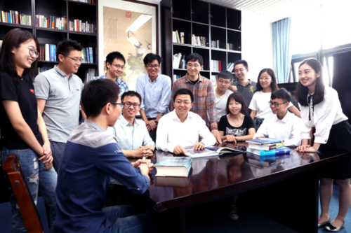
We currently have 1 professor, 1 postdoc, 5 PhD students and 1 undergraduate student.
We are Hiring!!!
We are constantly looking for students and postdocs.
Especially, we hope to recruit master's or doctoral students in computer science and technology, earth systems science, and other related majors at Tsinghua Shenzhen International Graduate School.
For postdoc, they would be working in our recently-started Tsinghua University - Xi'an Institute of Surveying and Mapping Joint Research Center for New Smart Surveying and Mapping or National Supercomputing Center in Shenzhen.
Postdocs and students in the group would receive the standard benefits provided by Tsinghua University, as well as a competitive additional package from the group.
Contact: haohuan@tsinghua.edu.cn, please send your CV, research statement, and 3 major publications.
Recent Research Highlights
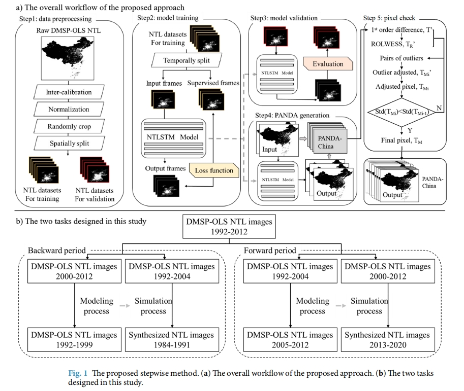
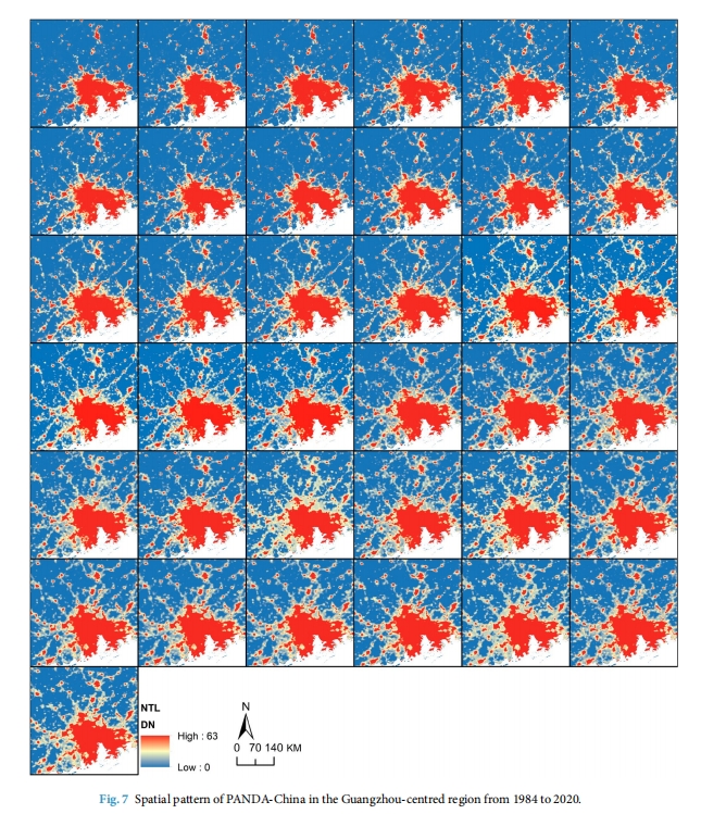
Nighttime light remote sensing has been an increasingly important proxy for human activities. Despite an urgent need for long-term products and pilot explorations in synthesizing them, the publicly available long-term products are limited. A Night-Time Light convolutional LSTM network is proposed and applied the network to produce a 1-km annual Prolonged Artifcial Nighttime-light DAtaset of China (PANDA-China) from 1984 to 2020. Assessments between modeled and original images show that on average the RMSE reaches 0.73, the coefcient of determination (R2) reaches 0.95, and the linear slope is 0.99 at the pixel level, indicating a high confdence in the quality of generated data products. Quantitative and visual comparisons witness PANDA-China’s superiority against other NTL datasets in its signifcantly longer NTL dynamics, higher temporal consistency, and better correlations with socioeconomics (built-up areas, gross domestic product, population) characterizing the most relevant indicator in diferent development phases. The PANDA-China product provides an unprecedented opportunity to trace nighttime light dynamics in the past four decades.
Spaceborne sensors with nighttime light (NTL) capabilities have served as an efective measure of various human activities over the past years. In recent years, the NTL data has provided a unique perspective on the intensity of lighting, which is related to the dynamics of socioeconomic activities and urban development. Te availability of long-term NTL data has triggered extensive eforts in multiple long-term research frontiers. For instance, mapping long-term urbanization processes benefts from the unique advantage of the NTL observations spanning a relatively long period, including urban extent, urban boundary, impervious surface areas, urban land use, and built-up infrastructure. Furthermore, long-term NTL datasets have proved to successfully estimate the population, the gross domestic product (GDP) and income, but also the poverty and freight traffic.
NTL datasets supporting the application above mainly derive from two groups. Te frst group is a primary NTL data source from the Defense Meteorological Satellite Program - Operational Linescan System(DMSP-OLS), which provides valuable records of global nightscape from 1992 to 2013. It has been widely used in socioeconomic felds even though sufering from the brightness saturation in urban centers and the blooming effect near the urban-rural transitions regarding its relatively long-term historical records. However, it is no longer available after 2013, which defines its time period as permanent 1992-2013. The second group of NTL dataset derived from satellites on track mostly started working since then, including Suomi National Polar-Orbiting Partnership-Visible Infrared Imaging Radiometer Suite (NPP-VIIRS), Luojia 1-01 satellite, and Jilin1-03b (Jilin-1) satellite and SDGSAT. As new generations of global NTL composites, they provided higher spatial resolution and fewer over-glow effects of the recorded radiance of NTL data compared to that of DMSP. However, their time spans are only available since 2012 at the earliest, resulting in a relatively short period for mapping the dynamics of human activities.
In all, even usable satellite NTL data has been publicly available since 1992, there is, unfortunately, no such dataset with high temporal consistency that spans from 1992 till now. Te quality and the available time span of existing NTL datasets limited their capability to reflect long-term spatiotemporal dynamics of human behaviour. Per these shortcomings and urgent needs, several attempts have been made to synthesize consistent night light time series across diferent platforms and sensors, which can be classifed into a new third group. Li et al. proposed an inter-calibration model to simulate DMSP/OLS composites from the VIIRS day-and-night band(DNB) composites by using a power function for radiometric degradation and a Gaussian low pass flter for spatial degradation (RMSE:5.00, R2:0.92). Zhao et al. conducted a sigmoid function model for generating a temporally consistent NTL dataset from 1992 to 2018 in Southeast Asia (R2: 0.91 in 2012, 0.94 in 2013). Li et al. generated an integrated and consistent NTL dataset using a sigmoid function at the global scale (1992-2018). Despite similar pilot eforts, it still lacks comprehensive and systematic evaluation frameworks for assessing the quality and reliability of the generated NTL dataset. Although statistical errors have been calculated, the temporal consistency of these datasets has been seldom checked and assumed in good accordance by default, which is not the case. Neither DMSP-OLS nor NPP-VIIRS has high temporal accordance owing to its manual-like pre-process recorded in ofcial documents, let alone that of a synthesized dataset deriving from these satellite datasets with diferent passing times.
To produce a longer-period NTL dataset as well as develop higher temporal consistency, we recommend the potential of historical records of DMSP be fully explored, with the help of newly adopted deep learning methods followed with a temporal consistency correction model. Te recent rapid development of deep learning approaches has provided a targeted and promising method in modeling the dependencies between the spatiotemporal dynamics of the DMSP-OLS. The LSTM architecture hereby has proved its capability in several spatiotemporally dependent applications, which is promisingly helpful in modeling the spatial and temporal dependencies of NTL data.
Considering the abilities of existing deep learning approaches in capturing the long-range spatial and temporal dependencies of NTL data remain to be improved, in this study, we propose a space- and time-aware approach named nighttime light convolutional long short-term memory network (NTLSTM) for modeling the relationship between dynamic changes of the long-term DMSP data followed with a temporal consistency correction method adapted from Robust LOcally WEighted Scatterplot Smoothing (RLOWESS) (Cleveland 1979). With the newly proposed method, we achieve the time series of NTL data in China spanning 1984 to 2020 for the frst time, affirm its temporal consistency, name it a prolonged artifcial nighttime-light dataset of China (PANDA-China), and analyze the spatiotemporal urbanization process at both national and regional scales using PANDA-China.


